• Trouble logging in? Send us a message with your username and/or email address for help.
New posts

Kaydence

Beach Fanatic
Jan 19, 2017
1,415
1,124
Florida
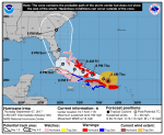
Meteorologist Jason Dunning sorta put this in perspective for me ... "This is a massive storm, close to being the size of Florida if you measure the distance of its cloud shield from one end to the other. The tropical storm force wind field is 320 miles wide. The hurricane wind field is 120 miles wide. There's a high chance most all of Florida will be impacted in some way based on the storm's expected movement along the peninsula."
21432858_1561034247288678_2195634717172096796_n.jpg
 

Lake View Too

SoWal Insider
Nov 16, 2008
6,872
8,316
Eastern Lake
Again, look at the NOAA Hurricane Center Website and you will see a real comparison of the width of the tropical storm winds compared to the size of Florida. The cloud cover is not the hurricane. 320 miles is not 400 miles.
 
Last edited:

Lake View Too

SoWal Insider
Nov 16, 2008
6,872
8,316
Eastern Lake
The Florida Peninsula is about 120 miles across. The projected center of the hurricane path seems to be around 50 miles off the eastern shore of the peninsula. The diameter of hurricane force winds is 120 miles. That means hurricane winds would occur about 10 or 20 miles inland, and tropical storm winds (39 MPH) might be felt another 100 miles inland. So, there might be almost no tropical storm winds on the west coast of the Florida Peninsula, and certainly none another 100 miles west of there, where we are. In other words, we are somewhere around 270 miles or more from the projected center and the extent of the hurricane's winds, of any kind, are maybe 170 miles or more away. Keep an eye on it, for sure, for any unforeseen moves, but it is significantly far from us. I think we need to prepare for an influx of refugees (however you do that) rather than any major winds or storm surge.
 

Leader of the Banned

Beach Fanatic
Apr 23, 2013
4,095
6,092
I look at this "overreaction" as kind of a drill. It's not a bad thing really.
 

Leader of the Banned

Beach Fanatic
Apr 23, 2013
4,095
6,092
I'm not so worried about tropical storm force winds. Plus if it hits Miami, and traverses up the middle of Florida, it's going to slow down considerably. I am concerned about the very real possibility that weather patterns could change and it could continue westward into the gulf. Then it could head north and the warm waters could keep it as a cat 5. I'm just saying it's possible. I wouldn't write it off.
 

Lake View Too

SoWal Insider
Nov 16, 2008
6,872
8,316
Eastern Lake
Oh, I agree, but we still have approximately three days, if it doesn't turn north and east, to evacuate. I have gas, I bought a bottle of water, but I'm thinking the batteries were suppose to be for remote controls and transistor radios, then I got confused...:blink:
 

Leader of the Banned

Beach Fanatic
Apr 23, 2013
4,095
6,092
The only time you should go outside during a hurricane is to turn off your sprinkler system if it happens to turn on, because shame on you for running your sprinkler while it's raining. Very wasteful!:nono:
 

Lake View Too

SoWal Insider
Nov 16, 2008
6,872
8,316
Eastern Lake
This is the 2AM Thursday Map from NOAA. The western edge of the cone has moved very little in the last 12 hours. If the cone drifts over past Cape San Blas, then the ballgame will have changed.3. Irma Track 2AM Thursday.png
 
New posts


Sign Up for SoWal Newsletter