


Story
Google Maps Street View Covering Every Inch Of Florida Beaches
August 15, 2013 by Kurt Lischka
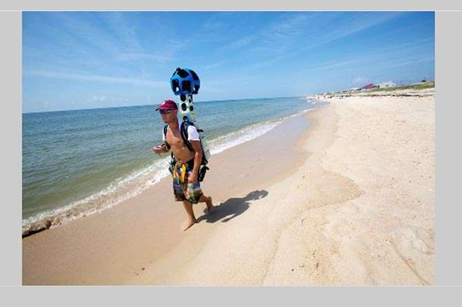
Greg Mathews and Chris Officer are wearing out flip flops every day as they walk Florida beaches for Google Maps. They are carrying a bizarre backpack which has a big blue orb overhead. The 40-pound rig contains 15 cameras that each take a picture every 2.5 seconds to later create a Google "street view" panorama. They are trekking about 7.5 miles a day for the project which is a collaboration between Visit Florida and Google.
The duo started in the panhandle and have already walked across South Walton. The project should be completed and accessible on Google maps in 2014.
From the AP story:
...Visit Florida has partnered with Google in the effort to map all 825 miles of Florida's beaches. And for good reason: tourism is Florida's top industry, accounting for 91.4 million visitors last year and $71.8 billion in spending that employed more than 1 million in the state.
The project began in late July when Matthews and Officer began walking from the Alabama-Florida border. After mapping Florida Panhandle beaches, they will hopscotch over to Florida's Atlantic coast and move south...
Read the amazing full story at:
http://bigstory.ap.org/article/google-maps-camera-toting-teams-map-fla-b...
See photos at:
http://www.visitflorida.com/en-us/slideshows/Google-Street-View-Camera-C...
Photo credit: Colin Hackley for VISITFLORIDA.com
Tagged

As a happy ambassador of South Walton, Kurt loves to share SoWal with the world through stories, photos, videos, texting, social media, and even telephone.