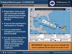
As of the 10:00am NHC advisory, Walton County is no longer in the 5-day error cone of Tropical Storm #Laura. While not in the error cone, we could still receive impacts from Laura.
According to the NHC the "earliest reasonable time" we could potentially start to see some type of tropical impacts is Tuesday. Widespread rainfall of 2-4" is possible with some areas seeing up to 6" especially closer to the coast, isolated flash flooding is possible, and dangerous surf and rip currents are expected.
All of these impacts and their exact timing are highly dependent on the exact track Laura takes and potentially can change as we progress through the weekend into next week.
Again, though out of the 5-day error cone we could still experience impacts based on this current track. Everyone should continue to monitor this system.
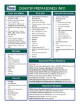
Now is the time to make sure you, your family, and your business are prepared. Check your disaster supply kit and continue to monitor Walton County Social Media, local media, and the National Hurricane Center.
The Atlantic Hurricane Season runs until November 30. Be sure to have a plan, build a kit, and be informed.
To sign up for emergency and weather notifications go to
www.alertwalton.org.
Know Your Zone. Know Your Home. To locate you evacuation zone visit
www.waltoncountyem.org.
WCEM will provide another update after the 4:00pm NHC advisory is released today.
Walton County Emergency Management

