• Trouble logging in? Send us a message with your username and/or email address for help.
New posts

Teresa

SoWal Guide
Staff member
Nov 15, 2004
30,325
9,318
South Walton, FL
sowal.com
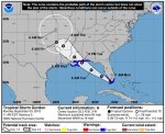
South Walton Fire District | Tropical Storm Gordon Update | Sunday Sep 3

At this time Walton County is not expecting any impacts from this system except for some heavy rains.


Along with Walton County Emergency Management, we are closely monitoring this system and updates will be provided as we recieve them.

Although there are NO Watches/NO Warnings for our area at this time, we are encouraging you to remain weather aware and track this system.

To recieve storm information specific to our area, always follow trusted media outlets such as:
South Walton Fire District
Walton County Emergency Management
US National Weather Service Tallahassee Florida
Walton County Sheriff, Michael A. Adkinson, Jr.
www.weather.gov
www.hurricanes.gov
FB_IMG_1535988131825.jpg
 

Teresa

SoWal Guide
Staff member
Nov 15, 2004
30,325
9,318
South Walton, FL
sowal.com
Tropical Storm Gordon 2pm Update
Sunday Sep 3
South Walton Fire District

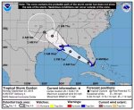
From Walton County Emergency Management-Tropical Storm Gordon is moving toward the west-northwest near 16 mph (26 km/h) and a west-northwestward to northwestward motion is expected over the next 72 hours.

It is possible that TS Gordon will be a strong Tropical Storm or minimal Hurricane at landfall late Tuesday.
The storm track has shifted slightly east and therefore Hurricane Watches and Tropical Storm Warnings have been issued for parts of LA, MS, and AL.

A Tropical Storm Warning has been issued from Escambia County to the Okaloosa/Walton County line but does NOT include Walton County.

Florida Outlook:
Impacts and timing have not changed. Locally heavy rainfall will remain possible and in the Panhandle, there will be increased rain chances on Tuesday and Wednesday.

Walton County Actions:
Continue Monitoring
Proactive social media messaging
Twice daily conference calls with the Florida Division of Emergency Management (FDEM)
Twice daily conference calls with the National Weather Service Mobile
Once daily conference calls with the National Weather Service Tallahassee

We ask that you remain weather aware and continue to track this storm. As always be sure you get your weather info from trusted sources such as
South Walton Fire District
Walton County Sheriff, Michael A. Adkinson, Jr.
Walton County Emergency Management
US National Weather Service Tallahassee Florida

FB_IMG_1536004472525.jpg
 

Kurt

Admin
Staff member
Oct 15, 2004
2,234
4,926
SoWal
mooncreek.com
Double Red Flags - no swimming allowed.

Okaloosa County schools closed.


tropical-storm-gordon-sept-4-7-am-fbb57633654ca533.png


Tropical Storm Gordon slowed down slightly early Tuesday morning (Sept. 4) as it moved through the Gulf of Mexico toward the coasts of Louisiana, Mississippi and Alabama. It's expected to make landfall Tuesday night as a hurricane near the Louisiana-Mississippi state line. Here's the track as of 7 a.m. Tuesday. (Image via National Hurricane Center)
 

Kurt

Admin
Staff member
Oct 15, 2004
2,234
4,926
SoWal
mooncreek.com
Fast-brewing Tropical Storm Gordon ended its sprint across the Gulf at around 11:15 pm EDT Tuesday night, making landfall just west of the Mississippi/Alabama border with top sustained winds estimated at 70 mph. Gordon’s impact on the coast was muted by its irregular structure. The storm never developed a solid, complete eyewall, despite several attempts to do so. By 1 am EDT Wednesday, Gordon's top winds had dropped to 50 mph. The storm was centered about 40 miles west of Mobile, AL, continuing northwest at a steady 14 mph.

Top sustained winds near Gordon on Tuesday night included 56 mph at Dauphin Island, AL, and 68 mph (gusting to 78 mph) at Fort Morgan, AL. Both sites are located at the south end of Mobile Bay, so they were affected by Gordon’s northern and eastern eyewall. The Dauphin Island reading was collected from a height of 44 feet and the Fort Morgan reading from 119 feet. It’s possible that no comparably strong winds will be reported from anemometers at a standard height of 10 meters (33 feet). See our two-part report from April on the challenges of measuring and assessing hurricane winds at landfall.

Even tropical-storm-force winds (sustained at 39 mph or greater) can be quite dangerous, as they can easily bring down trees and power lines, especially when the soil has been saturated by heavy rain. Escambia County authorities said that at least one person was killed Tuesday evening when a tree fell onto a trailer in West Pensacola, FL. At least 21,000 power outages were reported across coastal Alabama late Tuesday, and water overtopped highways in some flood-prone areas, including western Dauphin Island.
 
New posts


Sign Up for SoWal Newsletter