Walton County Emergency Management
Monday Oct 8
As of the 4am advisory Walton County was placed under a Hurricane Watch and a Storm Surge Watch. These mean that means that hurricane conditions (sustained winds of 74 mph or higher), and potentially life-threatening surge are possible within the specified area. Both are issued 48 hours in advance of the anticipated onset of those hazards.
Now is the time to ensure that you, your family, and your business are prepared. Have a disaster supply kit with at least 72 hours worth of supplies, have a plan of what you are a way to be notified of conditions and protective actions, and a plan for how you will respond.
To receive updates on Watches and Warnings sign up for AlertWalton at www.alertwalton.org, have a NOAA weather radio, and/or monitor local media and social media. A frequently asked questions sheet will be pinned to the top of our Facebook page throughout the event. It will be updated as new information is made available.
If you suspect a business of price gouging please call the Florida Price Gouging Hotline at 1-866-966-7226.
Walton County EM will continue to monitor this system and provide twice daily updates. Should you have any questions please email wcem@waltoncountyem.org or send us a message here on Facebook. A detailed situational awareness update is below.
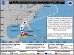
Tropical Storm Michael:
• As of 8 AM EDT Monday, Tropical Storm Michael was located about 120 miles east of Cozumel, Mexico, or about 630 miles south of Panama City, FL, in the Yucatan Channel.
• Maximum sustained winds are near 70 mph and Michael is moving north at 7 mph.
• Michael is expected to become a hurricane later this morning and is forecast to continue strengthening up until landfall. Landfall is currently forecast as a Category 2 with 110 mph, but a Category 3 is possible given the recent rapid intensification.
• Michael will continue to accelerate northward over the next 48 hours before making a turn towards the north-northeast or northeast as it makes landfall.
• Landfall is expected in the Panhandle or Big Bend sometime on Wednesday, and there remains some discrepancy in forward speed. A faster storm will make landfall on the western side of the forecast cone, where a slower storm will make more of a northeast turn into the Big Bend.
• Hurricane hunters will be investigating the system later this morning and again this evening.
Florida Outlook:
• Much of the Florida Panhandle and Big Bend remain within the cone of error for landfall potential.
• An increase in swells and rip current risks from Michael are already present and wave heights will continue to increase through Thursday morning.
• Tropical storm conditions may arrive in the Panhandle as soon as Tuesday morning but no later than late Wednesday morning.
• Hurricane Watches are in effect for 18 Panhandle and Big Bend counties between Pensacola and Cross City including Walton County. These may be upgraded to warnings later today.
• Storm surge will be one of the greatest impacts from this storm and may affect a large portion of the Florida Gulf Coast. Storm Surge Watches have been issued between Navarre (Okaloosa County) and Anna Maria Island (Manatee County) for possible surge inundation of 2-4’ for the Tampa Bay region and western Panhandle, 4-7’ for the eastern Panhandle coast, and 7-11’ for Apalachee Bay and Nature Coast.
• Widespread rainfall totals of 4-8” with locally higher amounts of 8-10+” can be expected across the Panhandle and Big Bend, with most of it occurring on Wednesday.
• Isolated tornadoes will be possible Tuesday-Thursday, but risk and where will depend on eventual track and intensity of the system (northeast quadrant relative to forward motion).
• Ocean swells from Tropical Storm Leslie and breezy onshore winds from high pressure to the north of Florida will continue producing a moderate to high risk of rip currents along all Atlantic beaches.
Walton County Information:
• Walton County is currently in the 3-day error cone
• Walton County is under a Hurricane Watch and Storm Surge Watch
• Walton County EOC moving to Level 2 Activation at 0900
• Walton County BCC Emergency Meeting at 1130 broadcast over Walton County EM Facebook Page
• Walton County Departments initiating hurricane response plans
• Twice daily conference calls with the Florida Division of Emergency Management and the National Hurricane Center
• Twice Daily conference calls with the National Weather Service Tallahassee
• Twice daily updates to the Walton County EOC team
• Proactive social media messaging
Monday Oct 8
As of the 4am advisory Walton County was placed under a Hurricane Watch and a Storm Surge Watch. These mean that means that hurricane conditions (sustained winds of 74 mph or higher), and potentially life-threatening surge are possible within the specified area. Both are issued 48 hours in advance of the anticipated onset of those hazards.
Now is the time to ensure that you, your family, and your business are prepared. Have a disaster supply kit with at least 72 hours worth of supplies, have a plan of what you are a way to be notified of conditions and protective actions, and a plan for how you will respond.
To receive updates on Watches and Warnings sign up for AlertWalton at www.alertwalton.org, have a NOAA weather radio, and/or monitor local media and social media. A frequently asked questions sheet will be pinned to the top of our Facebook page throughout the event. It will be updated as new information is made available.
If you suspect a business of price gouging please call the Florida Price Gouging Hotline at 1-866-966-7226.
Walton County EM will continue to monitor this system and provide twice daily updates. Should you have any questions please email wcem@waltoncountyem.org or send us a message here on Facebook. A detailed situational awareness update is below.
Tropical Storm Michael:
• As of 8 AM EDT Monday, Tropical Storm Michael was located about 120 miles east of Cozumel, Mexico, or about 630 miles south of Panama City, FL, in the Yucatan Channel.
• Maximum sustained winds are near 70 mph and Michael is moving north at 7 mph.
• Michael is expected to become a hurricane later this morning and is forecast to continue strengthening up until landfall. Landfall is currently forecast as a Category 2 with 110 mph, but a Category 3 is possible given the recent rapid intensification.
• Michael will continue to accelerate northward over the next 48 hours before making a turn towards the north-northeast or northeast as it makes landfall.
• Landfall is expected in the Panhandle or Big Bend sometime on Wednesday, and there remains some discrepancy in forward speed. A faster storm will make landfall on the western side of the forecast cone, where a slower storm will make more of a northeast turn into the Big Bend.
• Hurricane hunters will be investigating the system later this morning and again this evening.
Florida Outlook:
• Much of the Florida Panhandle and Big Bend remain within the cone of error for landfall potential.
• An increase in swells and rip current risks from Michael are already present and wave heights will continue to increase through Thursday morning.
• Tropical storm conditions may arrive in the Panhandle as soon as Tuesday morning but no later than late Wednesday morning.
• Hurricane Watches are in effect for 18 Panhandle and Big Bend counties between Pensacola and Cross City including Walton County. These may be upgraded to warnings later today.
• Storm surge will be one of the greatest impacts from this storm and may affect a large portion of the Florida Gulf Coast. Storm Surge Watches have been issued between Navarre (Okaloosa County) and Anna Maria Island (Manatee County) for possible surge inundation of 2-4’ for the Tampa Bay region and western Panhandle, 4-7’ for the eastern Panhandle coast, and 7-11’ for Apalachee Bay and Nature Coast.
• Widespread rainfall totals of 4-8” with locally higher amounts of 8-10+” can be expected across the Panhandle and Big Bend, with most of it occurring on Wednesday.
• Isolated tornadoes will be possible Tuesday-Thursday, but risk and where will depend on eventual track and intensity of the system (northeast quadrant relative to forward motion).
• Ocean swells from Tropical Storm Leslie and breezy onshore winds from high pressure to the north of Florida will continue producing a moderate to high risk of rip currents along all Atlantic beaches.
Walton County Information:
• Walton County is currently in the 3-day error cone
• Walton County is under a Hurricane Watch and Storm Surge Watch
• Walton County EOC moving to Level 2 Activation at 0900
• Walton County BCC Emergency Meeting at 1130 broadcast over Walton County EM Facebook Page
• Walton County Departments initiating hurricane response plans
• Twice daily conference calls with the Florida Division of Emergency Management and the National Hurricane Center
• Twice Daily conference calls with the National Weather Service Tallahassee
• Twice daily updates to the Walton County EOC team
• Proactive social media messaging
Attachments
Last edited by a moderator:


