
Applicant:
Go 3280, LLC
Jay Odom, Manager
PO Box 1735
4652 Gulfstarr Drive
Destin, FL 32540
NATUREVIEW PUD Development Phases
Phase 1 219 Residential Lots 2 Years
Phase 2 212 Residential Lots 1 Year
Phase 3 196 Residential Lots 1 Year
Phase 4 166 Residential Lots 1 Year
*Proposed development plan and timeframe subject to be adjusted based on market
conditions and demand
NatureView Planned Unit Development Application – MAJ21-000027
2
II. Project Description
The NATUREVIEW Planned Unit Development (“PUD”) site consists of four (4) parcels of
land located on both the north and south sides of County Highway 3280 (“CO HWY 3280”).
The four parcels are located approximately 0.7 miles east of the CO HWY 3280 / Magnolia
Lodge Road intersection within the unincorporated limits of Walton County, Florida. The site
is in Sections 3, 4 and 10, Township 2 South, and Range 18 West, and consists of Walton
County Property Appraiser Parcel Identification Nos. 04-2S-18-15000-001-0010, 03-2S-18-
15000-001-0030, 03-2S-18-15000-001-0000, 10-2S-18-15000-001-0000. The location of
the property is generally depicted on the Location Map which is contained in Appendix A of
this Application.
The Applicant is requesting approval of a Conceptual Planned Unit Development (PUD)
Masterplan which will consist of 793 single-family residential lots along with associated
infrastructure, civic and recreational uses. The NATUREVIEW PUD will be classified as a
Conceptual PUD as outlined by the criteria defined in Section 2.06.02(A) of the Walton
County Land Development Code (“County’s LDC”).
The NATUREVIEW PUD incorporates a total of 275.92 +/-acres. The entirety of the property
has a Future Land Use designation of Residential and a Zoning designation of Urban
Residential and was once part of the Black Creek Special Planning Area (BCSPA).
The subject property initially had a Future Land Use Designation of Black Creek Rural Town
Center, Black Creek Mixed Use Residential and Black Creek Low Density, see Appendix G
of this PUD document for historical Future Land Use information. The allowable density
associated with these Future Land Use designations would have been up to 1,503 units and
allowable commercial intensity would have allowed up to 2,175,822 square feet of
commercial space. During Walton County’s updates to the Comprehensive Plan and Land
Development Code in 2020 the Future Land Use designation were removed from the
property in error and subsequently these Future Land Use designations were deleted from
the Comprehensive Plan and Land Development Code essentially leaving the subject parcel
with no Future Land Use or Zoning designation.
Once this issue was discovered Walton County was obligated to apply new Future Land
Use and Zoning designations to the parcel that were comparable to the previous
designations. Walton County Planning proposed Mixed Use (MU) as a comparable Future
Land Use designation and Village Mixed Use (VMU) as an appropriate zoning designation
on 121.3 acres of the property and Urban Residential (UR) on 154.62 acres.
This change would have allowed a maximum density of 8 units per acre for residential uses within the
VMU district and 4 units per acre within the UR district, totaling 1,588 allowable units. The
VMU district would allow a Floor Area Ratio (FAR) of 2.0 for commercial uses within the
VMU district, totaling an allowable commercial intensity of 10,567,656 square feet.
The property owner supported the proposed amendments but requested that all four of their
parcels be designated as Urban Residential in lieu of the proposed Village Mixed Use and
Urban Residential designations. The requested change to Urban Residential on the four
parcels reduced the overall allowed residential density by 485 units and eliminated
commercial intensity which could have been up to 10,567,656 square feet. These voluntary
reductions in dwelling units and commercial development decreased potential impacts on
traffic, potable water and sanitary sewer services, garbage collection and demand for all
County services.
The Land Use Amendments to Village Mixed Use (VMU) and Urban Residential (UR) were
approved by the Board of County Commissioners (BOCC) on May 11, 2021, restoring land
uses and zoning to the NATUREVIEW project site for an allowable residential gross density
of 4 units per acre which, based on the acreage of 275.92 +/- acres, would allow a maximum
lot count of 1,103 units.
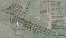
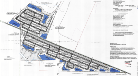
The NATUREVIEW PUD Masterplan will consist of 793 single-family residential lots along
with a club facility, swimming pool, pickleball courts, basketball court, playground, pocket
parks and public nature trails. These uses will be functionally integrated into a cohesive
development and connected by a multimodal transportation system comprised of streets,
sidewalks, and nature trails.
• Maximum Allowed Density = 4 units per acre (1,103 lots)
• Proposed Density = 2.87 units per acre (793 lots)

 sowal.com

 www.tampabay.com

 www.justice.gov


 sowal.com


