• Trouble logging in? Send us a message with your username and/or email address for help.
New posts

Kurt

Admin
Staff member
Oct 15, 2004
2,233
4,925
SoWal
mooncreek.com
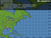
Tropical Storm Isaac has not strengthened overnight, with maximum sustained winds of 65 mph.

However, it is still forecast to become a hurricane. It's centered over the southeastern Gulf of Mexico nearly 400 miles southeast of the mouth of the Mississippi River. Isaac's west-northwest movement is expected to turn northwest on Tuesday. On that forecast track, the center will approach the northern Gulf coast in the Hurricane Warning area on Tuesday.


A Hurricane Warning continues from east of Morgan City, Louisiana, to Destin, Florida. This includes New Orleans, Lake Pontchartrain and Lake Maurepas. Preparations to protect life and property should be rushed to completion in the warning area. Additional Tropical Storm Warnings are in effect for portions of the Gulf coast.


Remember, do not focus on the exact track of Isaac due to the uncertainties in the forecast, and the fact that this storm has a large area of tropical storm-force winds, extending outward up to 240 miles from the center.
There is a threat of tornadoes over central Florida and the northeastern Gulf Coast through tonight, but the threat over South Florida will diminish this morning.
 

lenzoe

Beach Fanatic
From the National Weather Service:

Tropical Storm Warning
Statement as of 5:20 AM CDT on August 27, 2012

... Tropical Storm Warning remains in effect...

... Precautionary/preparedness actions...
precautionary/preparedness actions...

Final actions to protect life and property should be completed
before conditions deteriorate. Move patio furniture and other
loose outdoor objects inside.

Comply with any evacuation orders issued for your area. If your
home is vulnerable to high winds... or you live in a surge zone or
any location prone to flooding... evacuate to a designated shelter
or ride out the storm in the sturdy home of family or friends
outside of evacuation zones.


... Probability of tropical storm/hurricane conditions...
there is little chance for hurricane conditions at this time.
Also... the chance for tropical storm conditions at this time is
40 to 50 percent.

... Winds...
with the westward shift in the forecast track... sustained
tropical storm force winds are becoming less likely.
However... due
to the uncertainty in the forecast track... the Tropical Storm
Warning remains in place. Any eastward shift in the forecast
track could lead to a significant increase in the expected winds.
With the current track... maximum winds are expected to reach 25 to
35 mph with higher gusts... primarily Monday night into Tuesday.

So this morning Walton county is no longer under a hurricane watch.

Here's hoping Isaac remains a tropical storm.
 
Last edited:

Kurt

Admin
Staff member
Oct 15, 2004
2,233
4,925
SoWal
mooncreek.com
1. Walton County Schools will be closed on Monday, August 27th and Tuesday, August 28th. Decisions about the status of schools on Wednesday will be made at a later date as the storm is monitored.


2. There is currently a voluntary evacuation in place and a mandatory evacuation will be instituted on Monday, August 27 at 6:00am for all residents south of HWY 20 that are located in low lying areas and in flood zones A and B. These zones can be found on the Sheriff’s Office website atwww.waltonso.org.


3. All Walton County Government Offices will be closed for employees on Monday, August 27th and Tuesday, August 28th with the exception of essential personnel. Essential personnel will be contacted by their supervisors. Any employees who have questions regarding their reporting to work are requested to contact their supervisors.


4. Residents that are scheduled to report for jury duty on Monday, August 27th are requested to call the number on their jury summons between 10:00 pm Sunday, August 26th and 7:00 am Monday, August 27th for further information.


5. The BCC has rescheduled their regularly scheduled board meeting and items that fall under the agenda from Tuesday, August 28th at 9:00 am to Thursday, August 30th at 9:00 am at the courthouse in Defuniak Springs.
 

Kurt

Admin
Staff member
Oct 15, 2004
2,233
4,925
SoWal
mooncreek.com
at201209_model.gif
 

Attachments

  • at201209_model.gif
    at201209_model.gif
    38.6 KB · Views: 405

Kurt

Admin
Staff member
Oct 15, 2004
2,233
4,925
SoWal
mooncreek.com
As of 8 a.m. this morning, the Walton County Emergency Management Center will be operating at a Level 1 status (fully staffed and operational). The Freeport High School is OPEN as a Special Need and General Population Shelter at this time. Walton County is still expected to receive high winds and a large amount of rain, along with the potential for tornadoes. The next weather briefing will take place at 8:30 a.m. and after that, we will be able to release more information about how this storm will affect our county.
 

Alicia Leonard

SoWal Insider
NEWS RELEASE
Tropical Storm Isaac #5 update

For Immediate Release
August 27, 2012

Due to technical issues, the Walton County Sheriff’s Office website (www.waltonso.org) has temporarily crashed. This issue is being addressed at time and we will inform you when the page is back up and running. In the meantime, keep up with what is going on currently on our Facebook page, our sister Facebook page
, Walton Alert, and our Twitter page (wcsopio1).


Last edited:

Alicia Leonard

SoWal Insider
Via SWFD-
The beach flags for South Walton's beaches will be RED this morning. Double red flags will be flown by early this afternoon at that time we will be removing all Lifeguard Towers from the beach. This must be done before the outer bands of the storm arrive to ensure the safety of our staff. Thank you

Please take a minute to read the entire script below today and share this information with your friends and family, thank you.

Not a good day for paddleboards and kayaks as the winds and currents can push you away from shore and out past the second sand bar very quickly. It can be difficult to return to shore and very easy to capsize if you get side on to the wind.

Wave heights: Around 1-2 feet, with east northeast winds around 20 mph early. Waves heights are expected to build throughout the day.

Rip current risk: high a high risk of rip currents means that wind, wave and tidal conditions all support the development of strong and dangerous rip currents. Lake washouts and soft edges of sand bars can also add to rip current development. Rip currents have the potential to form very quickly at any location across the Beaches of South Walton. Deep channels between the sand bars are where the water brought in from the wave action funnels back out. Strong rip currents can take even the strongest swimmers away from shore. Please pay attention to the beach flags, if you are unsure whether rip currents are present, stay on the shore.

If you are unsure if rip currents are present, please check with a lifeguard, and stay on the shore.

IF YOU DON'T KNOW, DON'T GO....

Daily surf conditions and up to date beach safety flags can be seen at http://www.swfd.org/beach.php . For current Santa Rosa Beach weather conditions as well as our live Ed Walline and Rosemary Beach cam please visit http://www.swfd.org/weather.php, and lastly don't forget to text "Beachflag" to 67463* to receive up to date beach flag notifications on your mobile device.

 
New posts


Sign Up for SoWal Newsletter