I love seeing this thanks for posting - what do you remember about your time there?
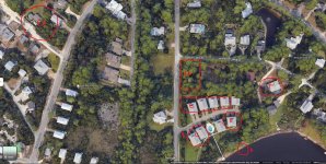
I tried finding an old aerial photo from 1973-ish but couldn't. If anyone can find one, please post, and I'll fill in the gaps. Hoping long time locals like Joyce Sunday can add to this.
This is a current view. Here's what I remember...
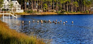
A: The dock pilings from my original pic above
B: The entrance to the camp. The drive went all the way through to the house labelled as F. Many memories of mosquito control coming through at night while we were all in the main building and fogging everything out; yet, I'm still alive!
C: Location of girls cabin. I think there were two buildings
D: Location of main building. One large building with big common area, kitchen, head counselor office, and a commissary for snacks and such
E: Activity buildings were across the drive. There were maybe three connected structures. The bow and arrow and rifle range were directly under the letter "E". Yes...we shot .22 rifles. Parish the thought! LOL!!!
F: Pretty sure this was the head counselors dwelling. It has been added on to and is still used. The wall that I mentioned above is in the trees at about the 8:00 position of my circle around F.
G: Upper left corner of picture. Boys cabins were up the hill. We walked up and down each morning and evening. If memory serves there were three...no more than 4...cabins. The last remaining one was knocked down not too long ago for new construction.
H: This was the rifle and bow and arrow range. It was a clear area except for the trees along Oyster Lake Dr. I'm sure there are a lot of trees with a lot of .22 bullets still in them!
Memories that stand out...
We were evacuated on the first night due to Hurricane Agnes to Ft Walton and spent time hanging out in the gym at what is now Meigs Middle School.
A couple days later we were all out sail boating and canoeing on Oyster Lake, and a waterspout came off the gulf. Tipped a couple boats over and ripped the roof off of the pump house up at the boy's cabins
Took my first breaths on a scuba regulator in Oyster Lake.
Fishing from the dock. There used to be tons of fish in there.
The house next to the camp had a boat, and they would ski every day on the lake.
Macrame...so much macrame. You want a hanging plant holder or a key chain? I think I still have a few!
Dances on Thursday nights I believe. Had my first slow dance with a camp counselor. I was a little kid, and let's just say I was the perfect height for a slow dance with an "older" woman! LOL!!
After the dance, the older kids would be gathered up, and we would walk up what is, now, Thompson Rd. It was a dirt road back then. Little did we know that other counselors had already gone ahead and were hiding amongst the graves in the cemetery. They would jump out and scare the crap out everybody.
It was a great time. That property sat fallow for years and years until the present condos were built. I used to go down there and do urban exploring on occasion until it was all gone.
