• Trouble logging in? Send us a message with your username and/or email address for help.
New posts

ShallowsNole

Beach Fanatic
Jun 22, 2005
4,292
849
Pt Washington
And the relaxing sound of jet engines as you sit on the back porch sipping cocktails.

And you will have absolutely no excuse to not come sip cocktails with me, as suddenly your house will be about 20 miles closer to mine. :D
 

Kurt

Admin
Staff member
Oct 15, 2004
2,233
4,925
SoWal
mooncreek.com
West Bay Parkway Meeting 6/23/11

The expressway to the aiport is something we've reported here before and keeping an eye on.
Check out the interactive map on the project website to see proposed routes.


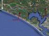
The Florida Department of Transportation is proceeding with developing a parkway which basically centers around the new airport. They have plotted several alternative roadway routes which will be the subject of the upcoming public meeting in Walton County. Also, as they said at the county commission meeting last night, a toll road is not off the table. They also indicated that "No build" remains an option. For all of those interested in this planned roadway, here is an announcement about the public meeting next Thursday.
Anita Page

SWCC Executive Director


COUNTY ROAD 388 / WEST BAY PARKWAY, SEGMENT 1, PUBLIC INFORMATION MEETING District: Three

Santa Rosa Beach Meeting
The Florida Department of Transportation (FDOT) invites you to attend a public meeting concerning improvements to CR 388 (West Bay Parkway, Segment 1) from US 98 in Walton County to SR 79 in Bay County [Financial Project Identification Number: 424464-1-22-01 and 424464-2-22-01]. Two meetings will be held, one in Panama City Beach and the other in Santa Rosa Beach, Florida.
The proposed West Bay Parkway, Segment 1 project, will extend CR 388 and provide a new four-lane, divided highway and potentially a new high-level bridge across the Intracoastal Waterway (ICWW). The PD&E Study will evaluate several alignment options north of existing State Road (SR) 30A (US 98). At the west end of the project, the study will determine the best location for the intersection with SR 30A (US 98) between CR 30 and CR 395 in Walton County. At the east end of the project, the study will determine the best location for the intersection with SR 79 in Bay County. The proposed extension is estimated to be between 11.5 and 19.0 miles long, depending on the alternative alignment selected. Seven alternative alignments will be presented at the meeting.
These Public Meetings are being held in order to inform the public of the project progress and schedule, and to receive input on the project’s seven alternative alignment options. Aerial maps will be on display and project representatives will be on hand before and after the presentations to discuss the project and answer questions. Comment sheets will be collected at the meetings.
Public participation is solicited without regard to race, color, national origin, age, sex, religion, disability or family status. Persons who require special accommodations under the Americans with Disabilities Act or persons who require translation services (free of charge) should contact Brandon Bruner at least seven days prior to the meeting.
 

Attachments

  • mao.jpg
    mao.jpg
    70.7 KB · Views: 521
Last edited:

Kurt

Admin
Staff member
Oct 15, 2004
2,233
4,925
SoWal
mooncreek.com
The Florida Department of Transportation (FDOT) is proposing a new four-lane roadway, approximately 24 miles in length, referred to as the West Bay Parkway. The engineering firms of H.W. Lochner, Inc. and PBS&J have teamed together and are under contract with FDOT to conduct a Project Development & Environment (PD&E) study for the proposed West Bay Parkway (CR 388 Extension). During this study, potential locations for the new roadway will be identified and analyzed to document the impacts (both positive and negative) of the alternatives that are developed.

The overall project limits are from US 98 (SR 30) east of Peach Creek in Walton County to SR 77 in Bay County; however, the project will be divided into two segments (refer to the project map), with each segment having its own PD&E study.

The benefits of the new facility include improving mobility and interconnectivity in the regional transportation network and enhancing traveler safety. Additionally, the improvements will provide better access to the new Panama City-Bay County International Airport, improve hurricane evacuation and emergency response capabilities, promote economic development in the region, and increase capacity and relieve existing and anticipated traffic congestion, particularly along the US 98 corridor.

One of the first steps in identifying potential locations for the new roadway is to develop alternative corridors (which vary in widths from 500 to 1,000 feet). Through the utilization of Land Suitability Mapping (LSM), the project team has identified nine alternative corridors for Segment 1 and eight alternative corridors for Segment 2. These alternative corridors are currently under review and are being analyzed. To learn more about the LSM process and how these corridors were developed, please click on the LSM Technical Memorandums on the side menu.

Since the actual right-of-way required for West Bay Parkway (a range of between 150 and 350 feet, depending on the type of roadway that is ultimately selected) will be much less than the corridor widths, potential locations for the roadway can be developed within the corridors during the next phase of the PD&E study.
 
Last edited:

soappedaler

Beach Fanatic
Feb 21, 2006
427
121
West Bay Parkway

Went to a meeting tonight for the West Bay parkway. This is a road from the airport in Panama City to Walton County. Donnie Bush of Bruce, speaking during the public comment section, stated that most of the alternative routes would have a negative impact on the Ivory Billed Woodpecker and likely cause it's demise in this part of the world. He had pictures and gave me one. There will be more public meeting on the project in the future. The only alternatives that would not impact the bird is route#2 or the no build option.

Edit- Just went to the website and the maps there are different than what was presented.
 
Last edited by a moderator:

soappedaler

Beach Fanatic
Feb 21, 2006
427
121
Donnie Bush who spoke during the public comment section gave me a photo of the bird he saw. It looks like an ivory bill to me from the head, distinct black on top red on the side http://www.fws.gov/ivorybill/images/Sibley-art-for-web.gif. The map you have posted is not what was presented at the meeting. The northern most segment green on your map has been eliminated. That route did not have a connector to 30A. The remaining alternatives dump traffic on 98 north of St. Joe's property so to get to 30A St. Joe can build a road through, or adjacent, to their golf course or use the exiting road they have. No build was mentioned as an option and hopefully will be the ultimate outcome.
 

beachmouse

Beach Fanatic
Dec 5, 2004
3,504
741
Bluewater Bay, FL
The possible ivory billed is only one of many endangered species in the area whose habitats can impact road-building. There's a proposed Hurlburt bypass road to the west that's gotten pushed back indefinitely because of endangered salamander habitat concerns.
 

Em

Beach Fanatic
Sep 18, 2005
1,506
884
Walton Co.
soappedaler, please post the photo of the ivory billed woodpecker. I would love to see it. I've always kept that bird in the back of my mind, and my camera poised, ready to shoot if I'm lucky enough to see one. I think any decent real photo would be worth several hundred thousand dollars to the photographer as it would surely hit National Geographic.
 

Kurt

Admin
Staff member
Oct 15, 2004
2,233
4,925
SoWal
mooncreek.com
Donnie Bush who spoke during the public comment section gave me a photo of the bird he saw. It looks like an ivory bill to me from the head, distinct black on top red on the side http://www.fws.gov/ivorybill/images/Sibley-art-for-web.gif. The map you have posted is not what was presented at the meeting. The northern most segment green on your map has been eliminated. That route did not have a connector to 30A. The remaining alternatives dump traffic on 98 north of St. Joe's property so to get to 30A St. Joe can build a road through, or adjacent, to their golf course or use the exiting road they have. No build was mentioned as an option and hopefully will be the ultimate outcome.
Their website is stil showing the green route. Any word on why it was eliminated?

It doesn't look like any of the proposed roads connect to Scenic 30A. Do you mean connect to a current road which connects to Scenic 30A like WaterSound Parkway? Or a new road from 98 to Scenic 30A?

I would guess alt 6 or 7 would be the number one option as it is to the west of WaterSound and looks like it is close, maybe through, the St. Joe commercial park and close to WaterSound Pkwy, the existing connector to Scenic 30A.

I wonder if there would be an on/off ramp for Bunker? I suppose there are plenty of landowners north of the Intracoastal yearning for ramps.

Was there any talk of wetlands or bridges over wetalnds? How about wildlife underpasses?
 
Last edited:

soappedaler

Beach Fanatic
Feb 21, 2006
427
121
No mention of why they made the changes. That elimination of the northern most route is not the only change, it appears that a more southerly route has been added. I don't have a scanner or I'd scan the new map and photo. I will bring the photo to the market with me on Saturday(8-12) so anyone wanting to see it can come by. The consultant said the next meeting will be sometime in the Fall of 2012. Remember that NO BUILD is an option.
 
New posts


Sign Up for SoWal Newsletter