US National Weather Service Tallahassee
Monday August 16
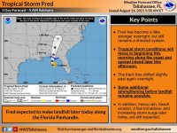
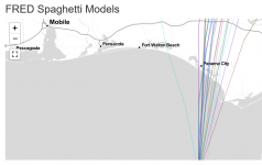
Aug 16 - 5am ET Update on #Fred. The track has shifted east slightly with the update this morning and some additional strengthening before landfall remains possible. Advertised impacts have largely remained constant (and we'll go through those impacts below).
WIND: Tropical storm conditions are beginning to move onshore across our coastal counties and expect these conditions to move inland through the morning and afternoon ahead of Fred's landfall later today. These are some of the impacts folks should already be prepared for.
RAIN: Amounts have come up and shifted north and east some with this update. Storm total amounts are forecast to be 4 to 8 inches, but isolated locations under training storms could see up to 12 inches of total rainfall. A Flash Flood Watch is in effect
SURGE: The surge forecast remained unchanged overnight. The highest values are still expected to be across the Apalachee Bay later this evening during high tide. Up to 3-5 feet of inundation is possible from Indian Pass east to the Steinhatchee River.
BEACH: High surf warnings are now in effect with surf heights of 7 to 12 feet possible. You should NOT be in the water today.
TORNADO: As with most tropical systems there is usually a threat for tornadoes, #Fred is no exception. The threat will be greatest across our FL counties today, but all locations across our forecast area are at risk for a few tornadoes.
#ALwx #GAwx #FLwx #TropicalStormFred weather.gov/tallahassee

